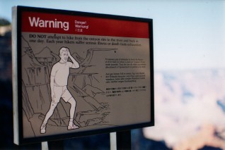
Woke up at 5:30am and it was still dark and I have to admit to having doubts about trying to hike down and up in a day. My contacts on-line said it was definitely not easy but they'd done it. Everybody else thinks it's a real bad idea. Only one way to find out.
There are two maintained trails that descend the Canyon's South Rim; not wanting to miss out on anything I opted to go down one and come up the other. South Kaibob is the steeper of the two, so it makes the most sense to follow it down and come back up on Bright Angel. Plus the Bright Angel trailhead falls right outside my cabin door so when I finish I can crawl home if I have to. I need to take a bus to the South Kaibob trailhead, because it's a few miles away.
 |
| "It certainly is." ... 7:30am at South Kaibob Trailhead. |
Drank the coffee I bought last night in Flagstaff, now cold. Ate a turkey sandwich. And two granola bars. Hey, it's not ideal but it's 5:30am and there's nowhere to get a real breakfast. I'd planned to start hiking around 6, in time to catch sunrise at 6:20. Didn't realize the bus was going to take fucking forever to get me to the trailhead. It was running late - as if there were traffic? And it drove the entire distance at about six miles per hour and stopped every fifty feet.
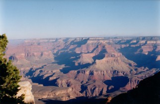
By the time I got to the South Kaibob trailhead it was 7:30am - not a good start. Keep in mind I arrived well after dark last night and it was dark when I left my cabin for the bus this morning so I got my first view of the Grand Canyon here at the trailhead. I know it's a cliche but I couldn't help think that it certainly is.
The morning was beautiful and kind of cool for the first part of the walk, and I walked with a woman from Connecticut for about forty minutes or so. The first half of this trail is in the shade of the canyon and in the early morning it's kind of cold but that changes quickly enough. Drank regularly but conserved water, as there's none to be found anywhere on the way down and the next available water is at the bottom. The trail is definitely steep, though not difficult. Biggest danger so far is getting distracted and slipping and twisting something - almost slipped a couple times but had great boot support.
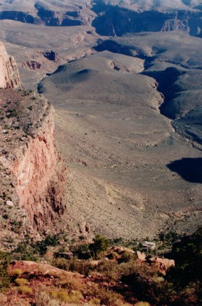
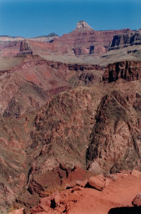
Three-quarters of a mile down the trail is Ooh-Aah Point - I'm not making this up, that's what it's called. Presumably a sixth-grader won the contest to name this locale. There's no sign or anything when you get there, but you know when you're there.
 |
 |
| Above and right: A pair of views from the unfortunately-titled Ooh-Aah Point. |
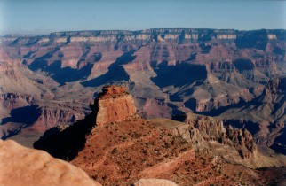
After Ooh-Aah Point the trail gets narrower, sometimes steeper, and at times runs right along the edge of a pretty severe drop, so I wouldn't recommend heading too far past this point if you have a fear of heights. From here the trail also breaks out into sun and warms up a bit. It's another three-quarter mile to the next stop, Cedar Ridge. Passed a group of backpackers who'd spent the night on the canyon floor and were on their way back up. They asked how far I was going and when I told them they warned me against it, and suggested I carefully consider what I think will be my... I believe the phrase was "point of no return", meaning at what point I have to recognize there's not enough time to get back and need to turn around.
 |
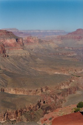 |
| Above and right: Views from the trail beyond Ooh-Aah Point. |
 |
| The long, narrow trail to Cedar Ridge. |
 |
| Cedar Ridge, seen from above. |
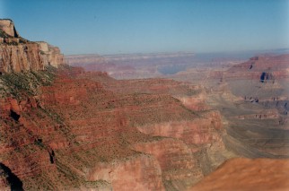
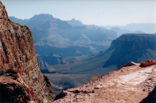
Cedar Ridge is one and a half miles from the trailhead, and the point where the park recommends first-time hikers turn back. There's a little restroom shack, which works on a compost system. The photo on the left was taken from a ways above Cedar Ridge, and you can see the little shit shack.
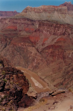
Met a hiker here who said the trail to the river would be less steep than I'd experienced so far. She told me what to do at the bottom to find the other trail back up, and then advised against descending to the river. Passed little designated stopping points along the rest of the trail, but they're either marginally or not at all identified so I passed. If you go far enough down the trail you get a spectacular view of the muddy Colorado River, which winds along the bottom of the Canyon.
You encounter far fewer people the closer you get to the bottom, as most dayhikers turn back early and this leaves only backpackers and crazy people like me. Every once in a while a mule train comes by carrying tourists, and all hikers have to find a place to stand while they pass by, kicking up dust and shitting all over the place. Apparently this is a popular attraction although I fail to see why.
On a couple of occasions I came across a pile of backpacks lying on a stretch of trail that's empty in either direction as far as I can see, on a sheer cliff-face. Rock climbers? No ropes. weird.
 |
 |
| First view of the Colorado River. |
The red clay in the lower right is the road |
Over six miles of trail from the South Kaibob trailhead the path passes through a short rock tunnel and opens on to a black bridge that spans the Colorado River. Once you cross the bridge it's a mile hike down to the second, silver bridge that you use to recross the river and start the hike up the Bright Angel Trail. Reached the bottom around 11am, so I was making really good time having hiked down in three and a half hours, with seven and a half hours to get back out.
The mile hike along the river to the second bridge was almost completely flat, as it runs along the bottom of the canyon. You can and should stop and soak your clothes in a stream that runs alongside the river, but you don't want to get near the river itself as the current is incredibly strong and has a history of sweeping people away. Just off the black bridge I met a couple who were hiking down and up the South Kaibob trail on the same day - the first people I encountered with the same idea. This came as a bit of a relief; although by now I had great confidence in The Plan, I was worried because I hadn't encountered anybody else who was trying it.
Just before the silver bridge I found a water source and refilled all three bottles. The silver bridge is probably a little unnerving for anyone with heights issues, as it's fairly high above the river, it's really narrow, and it's made up of loosely-attached metal grates that clang and shift under your feet.
 |
| Left: Sheer cliff-face, check out the relative size of two backpackers in the foreground. |
Just across the bridge I encountered a couple in their sixties stretched out on a rock. I told them I had just come down South Kaibob and was about to start heading up Bright Angel Trail and they admitted to having the same plan.
"We just came down Kaibob," said the woman.
"We saw a rattlesnake!" the man added.
"Oh yes, and it was really beautiful. We took its picture."
"People seem to think we're crazy," they said. "At one point we encountered this wise old man of the canyon, and when we told him what we were doing he just looked sad and shook his head slowly".
We all laughed, partly at the caricature of the Wise Old Man of The Canyon, and partly because we really were being kind of stupid. I said that so far it didn't seem so bad provided you did a little research and brought along the right stuff.
"Oh I found out what to do on the internet!" the woman enthused.
The man added he'd brought along 'about a million Power Bars' so they weren't concerned.
Stopped for a quick lunch but didn't rest too long just in case. The next stretch was going to be fairly difficult as it was around noon and a hundred and ten degrees with no shade in sight. Also there was nobody anywhere in sight. The Bright Angel trail differs from South Kaibob in that it's less steep, offers more shade near the top, and has occassional soucres of water. On the down side it's about two miles longer and ascends to a point 400 feet higher than South Kaibob trailhead.
Hiked for a while under a scorching sun when I realized the trail was barely climbing. Couldn't even see the South Rim and was seriously starting to wonder how long it would take to get back up. I walked at least an hour without seeing another person, and after I got tired of singing and talking to myself I encountered the unanticipated problem of sheer boredom. Sure the view in every direction is spectacular, but I've been looking at it all for five or six hours and am running out of things to think about and starting to go a little crazy. I reached a point where I finally stopped taking pictures; the process of changing lenses and rolls of film started involving more effort than it used to, and the camera strap was chafing my neck.
It seemed to take forever to get to Indian Gardens, a spot four and a half miles from the top with water and a restroom. From this point on I was back in civilization, as a lot of dayhikers go as far as this point down Bright Angel before turning around and heading back up. I'd consumed the better part of the supplies, and was feeling fine other than starting to get kind of sore in the legs. The next few hours were more of the same, but I found that my need to stop and rest was increasing in an exponential and alarming kind of way.
The last few hours lasted forever, but I dragged my sorry ass up the last few miles to the Bright Angel Trailhead, and after eight and a half hours I'd covered almost seventeen miles of trail and a change in elevation of almost nine thousand feet. Although my legs were sore everything seemed to be working otherwise. I must have been exhausted by the experience because looking back most of what I did in the next five hours didn't make a lot of sense.
 |
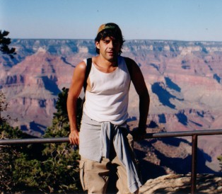 |
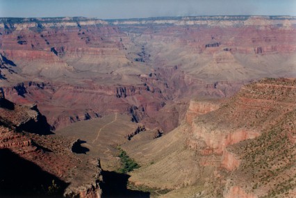
| View of canyon from Bright Angel trailhead, 4pm. |
See? Not dead. Happy. |
Didn't walk straight back to my cabin, which was close to the trailhead. Instead I walked straight to the Bright Angel Lodge's bar and ordered a vodka soda, which I drank while talking to a Mexican bus driver from San Diego.
I entered the Bright Angel Restaurant and had good minestrone soup and okay chicken sandwich, and other things that I can't remember. Finished eating and realized it was only 4:30 and had somehow started the trail an hour late and finished two hours early. Tried to find the lost time but couldn't think straight. Went back to my cabin, took a long shower. For some reason I decided if I fell asleep before 9 I'd wake up at 3am so I stalled. By 7:30 I knew I had to leave the cabin or I'd fall asleep, so I decided to eat dinner again.
Walked to the Bright Angel Lodge and asked a clerk at the front desk how to get to the cafeteria. The clerk gave me directions that I couldn't follow, so I went outside and wandered around in a dark parking lot behind what I think may have been a power plant. Got frustrated, retraced my steps to the cabin, got in the car, and drove to the cafeteria because I thought it would be easier if I had road signs to follow. Drove to the cafeteria in about two minutes.
Parked the car, entered the Maswik Cafeteria and halfway through my request for what I did and didn't want on my burrito I started speaking Spanish. Ate the chicken burrito and rice. Drank a big glass of orange juice. Got back in the car, got lost, and drove around the cafeteria four or five times before a nice couple explained how to get back to the Bright Angel cabins. Saw a skunk and a white rabbit . Part of me wanted to jump out and follow the rabbit. But then I remembered about Alice when she ran down the hole, and the only hole I knew of in the area was a really really big hole, and besides I'd already spent the better part of the day going into it and coming back out again.
Went home.
Slept.
Day Seven, Grand Canyon, AZ to Gallup, NM:
Little Colorado River Canyon. things from outer space. Winslow. got my kicks.
back to Day Five, Phoenix, AZ to Grand Canyon, AZ:
ghost towns. long desert roads. purty mountains. dark woods.