|
Took a long time to get out of Phoenix. Started late, around 10, and stopped again at Sun Bowl Plaza for a quick look through the vintage stuff. I didn't find much which would seem surprising given the sheer quantity, but you can't do thrift in a hurry.
Passed up Interstate 17 for the Routes 60 to 89 option, which allowed me the full complement of fun sites along the way. First up about an hour northwest of Phoneix and just outside the very small town of Congress, is a geunine ghost town. There's an art to ghosttowning --yes it's a word-- and I picked up a lot of information from the book Arizona Ghost Towns and Mining Camps. Another great resource is the tremendously entertaining www.ghosttowns.com, which offers an astonishing amount of information on ghost towns in every state. You'd be surprised to learn how many there are; hundreds in Arizona alone. And they're not easy to find, but with a little research you can search them out.
 |
 |
 |
 |
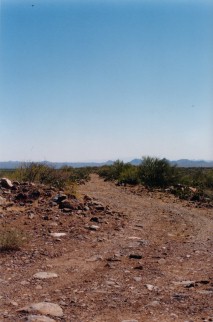
Stanton is not a tourist mecca with historical reenactments, refreshment stands, and a paved parking lot where you can lose your family's minivan amidst a sea of other families' minivans. To reach Stanton you leave what I would hesitate to call a highway and follow a rough dirt road for about eight miles through the desert. I did not rent an SUV because it is a status symbol. I rented an SUV because I knew I was going to Stanton.
A small mining town built in the early 1870's, Stanton has a violent and bloody history, an inspiration to Western writers everywhere. Known first as Antelope Station, the town was renamed in 1875 after the man who showed up and took advantage of some kind of pig-related incident to elminate the owners of the stage station and the general store. After successfully landing one man in prison and one in the grave, Charles Stanton hired desperados to kill the general store owner's silent partner, and in 1886 allegedly became involved in circumstances leading to the charred remains of the last remaining person in power, and his entire family. Later that year Stanton was shot dead, not because of his systematic elimination of leading townspeople, but because he insulted a man's sister. So there is a happy ending after all. The town died when the post office closed first in 1890, and again in 1905.
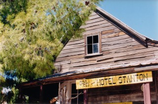
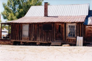
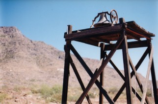
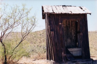
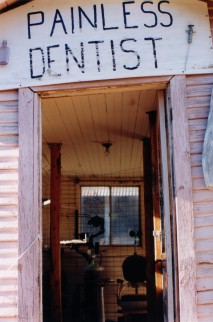
Today Stanton is a collection of three somewhat-restored buildings that you can visit if you can find it. Leaving the car I passed a handwritten sign warning that a mountain lion was currently making regular visits to the premises, and onto the porch of the stage stop and store in which Charles Stanton was shot dead over a hundred years ago. The relaxed man in the old wooden chair actually said by way of introduction, and I quote: "Hot enough for ya?". It felt so movie-like I didn't feel it would be appropriate to answer with anything other than "ayup". We chatted briefly. Somehow I developed a drawl.
The other two buildings are the Gold City Hotel Stanton and the saloon/recreation hall. There are a number of other small shacks and building remains among the grounds to see. And dust. And lizards. Many, many lizards. I drove another mile or so up the road to look at more remains and more dust and lizards, then back to Route 89.
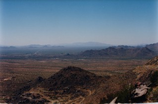 |
Almost immediately after rejoining Route 89 from Stanton the road veers almost straight up the Weaver Mountains, offering a spectacular view of Southern Arizona desert. After passing through a few small towns the road winds dramatically through the Prescott National Forest and eventually into the town of Prescott.
Prescott is a nice enough town with a historic town square flanked by "whiskey row", which was home to all sorts of interesting activities at the turn of the century. Founded in 1864 by gold prospectors, Prescott is Arizona's first territorial capital. Around 2:30 I stopped for lunch at Zuma's on North Montezuma. Zuma's is a good-sized bar and restaurant with a creative menu and really good food. Ate a big southwestern chicken salad and got back on the road.
 |
 |
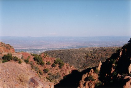
By 4 I was on Route 89A North and driving through a valley across an expanse of yellow fields. The road winds up another chain of mountains for a scenic drive that leads directly into the town of Jerome. A former ghost town, Jerome is perched on the northern side of a mountain that overlooks mountainous northern Arizona and the red rocks of Sedona. Although the town is now active, it's still intersting to visit with its winding streets and spectacular view - I wish I had more time to spend here but had a long way to go to reach the canyon. Made a quick stop at the ghost town, which lies just outside the downtown area. Paid a small fee in the gift shop then entered into a collection of old buildings ringed by rusting heaps of equipment and a free-roaming braying donkey.
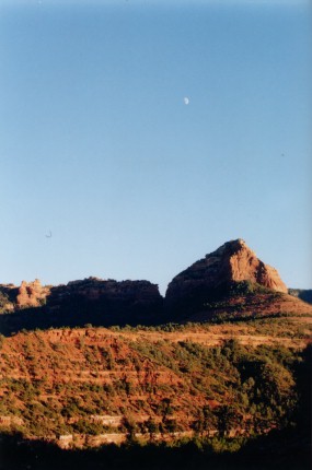 |
Route 89A winds down the mountain, and after leaving Jerome continues through a small suburban area and eventually to Sedona. Northern Arizona differs from southern in that the higher elevation allows for more reasonable summer heat. So it's not surprising to find more expansive suburban areas, especially near Sedona which is a major tourist destination. Didn't get much chance to see Sedona, as a lot of the road was under construction and when I arrived at 5:30 daylight was threatening to quit. The drive is enjoyable, and once you're through there's another pleasant drive through Oak Creek Canyon to Falgstaff. This route is repeatedly labeled as scenic by a series of signs, but I was more impressed with the mountain roads to Jerome over the canyon forest.
Pulled into Flagstaff around 6:30 with the sun sinking slowly behind the gas stations and strip malls. Flagstaff is pretty cool, it feels like a big college town, which it is, and the first place I hit Route 66- though not the place to experience authentic Route 66. Despite the fact that Flagstaff was settled by a flock of sheep in 1876 it's very modern today and Arizona's fourth-largest urban area.
Had a decent burrito for dinner at a small place off Route 66 staffed by grumpy college students, and went in search of supplies for the Canyon hike. A helpful guy in a combination video/cigar store gave me directions to Safeway, where I picked up sandwiches, dried fruit, lots of water, and more road coffee.
Once you clear Flagstaff, Route 180 North after sundown is the most fun road to drive anywhere. It bears due north, winds occasionally, has almost no turn-offs, nobody else in sight, and is pitch black. You can take it at about 80 mph with the windows rolled down and turn the Lost Highway soundtrack all the way up to eleven. I know because I did this, and can attest to the fact that there's nothing like Marilyn Manson screaming over the rushing wind in a pitch black forest under a starry sky.
I arrived at the entrance to the South Rim of Grand Canyon National Park at about 9pm, apparently the best time to show because the booth where people take your $20 entrance fee had no people in it but a hand-written sign taped to the window that says "pass on through". And I did.
I checked into Bright Angel Lodge, one of the hotels operated inside the park, perched on the edge of the South Rim. I pulled up to my little cabin, watched a deer shuffle around for a bit, and brought all my stuff inside. Bright Angel Lodge is on the cheaper end of the Park's lodging options. It's often described by people as "rustic", which can mean any number of things, but the little cabins are great - they're comfortable and much less sterile than hotels. Make your reservations early; everyone wants to stay inside the park but not everyone gets to. Loaded the backpack for the next day and got everything ready; it's going to be an early day and a long one if I want to achieve... semi-dangerous plan. Cue ominous music. Fade to black.
Day Six, Grand Canyon, AZ:
down. up.
![]()